I am so excited to share this incredible round-up of southern Utah hiking trails.
From slot canyons and secret ladders to canyon overlooks and hoodoos, these trails are sure to impress every hiker!
Let’s jump right and introduce you to 20 of the best hiking trails in southern Utah!
Southern Utah Hiking Trails Near Kanab
1. Wire Pass Trail
Difficulty: Moderate
Length: 3.7 miles
Type: Out & back
AllTrails Link: Wire Pass Trail
The Wire Pass Trail is located in the Paria Canyon-Vermilion Cliffs Wilderness Area, just a short drive from Kanab, Utah.
This hike requires you to drive several miles down a dirt/washboard road to reach the trailhead, but just about any vehicle should be able to make the drive as long as you are driving slowly and cautiously.
There is a permit fee of $5 per person, and dogs are also allowed at an additional cost of $5 per dog.
The majority of this hike is in an exposed wash, so it is best to complete the hike early in the morning or in the evening to avoid the heat of the day.
Be sure to bring plenty of water for both you and your dogs.
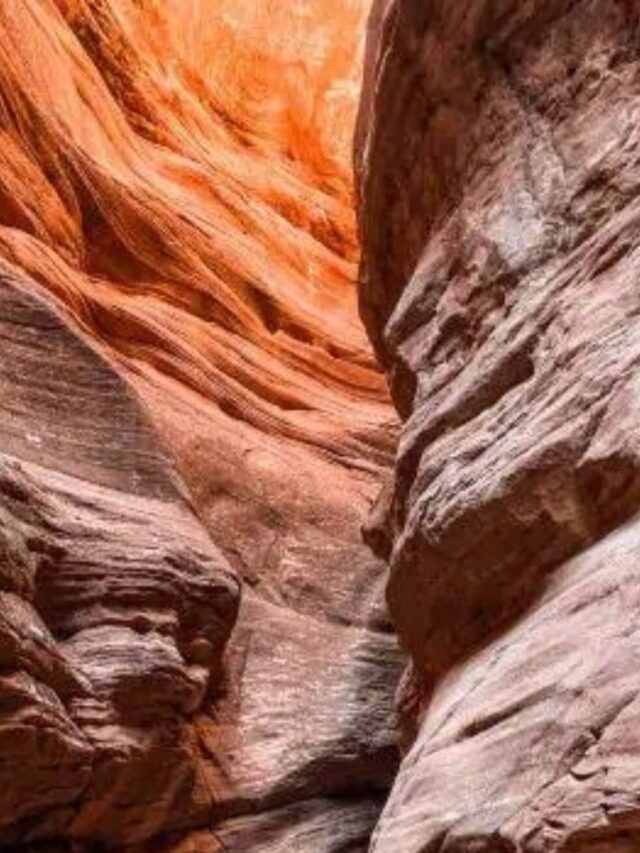
After hiking over a mile, the wash starts to narrow and form the slot canyons you will be looking for.
They are fairly tight but still wide enough to hike through easily.
Partway through, you will come to the famous wooden ladder and need to climb to continue your hike.
This part is more difficult if you do have dogs with you, so keep this in mind if you plan to complete the entire hike.
Once you’re down the ladder, you can continue hiking through the slot canyons to view the nearby petroglyphs.
Overall, this is a fun hike for everyone and should definitely be one of your top bucket list destinations in Utah!
Are you looking for other slot canyons? Check out this post with the best Utah slot canyons!

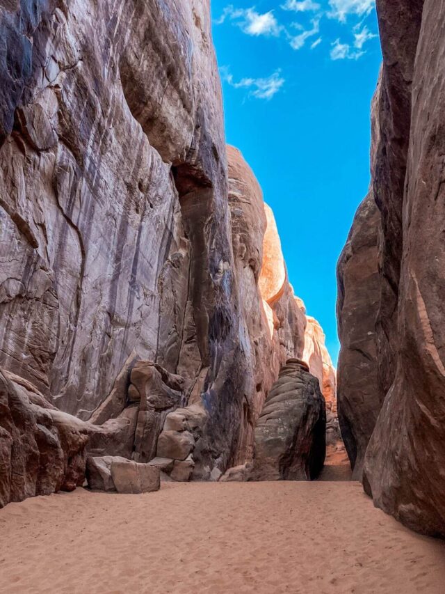
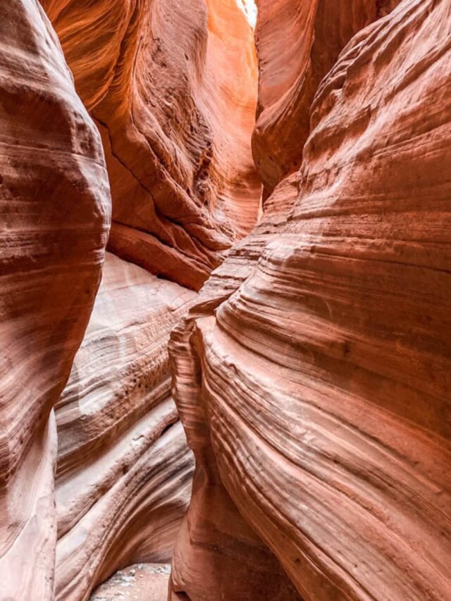
2. Peekaboo Slot Canyon Trail
Difficulty: Moderate
Length: 8.1 miles
Type: Out & back
AllTrails Link: Peekaboo Slot Canyon
Peekaboo Slot Canyon is arguably one of the prettiest slot canyons in Utah and is one of the most Instagrammable places in Southern Utah!
It is similar to the nearby Antelope Slot Canyons but far less commercialized.
You can reach this slot canyon by hiking over 8 miles round-trip through sandy trails.
Once inside, the slot canyon varies in width, with some areas winding tightly and others opening up.
The colors of Peekaboo Slot Canyon are vibrant and swirl with pinks, reds, and oranges.
They are prettiest in the evening, with the sun setting and casting light over the edges.
It is best to hike this trail early in the morning or late in the evening to avoid the heat of the day in the summertime.
An alternative to hiking this trail is taking an ATV tour to Peekaboo Slot Canyon.
We did an ATV tour and a canyoneering tour in the area and really enjoyed both!
If you are looking for something extra fun to do, I highly recommend taking one of these tours.

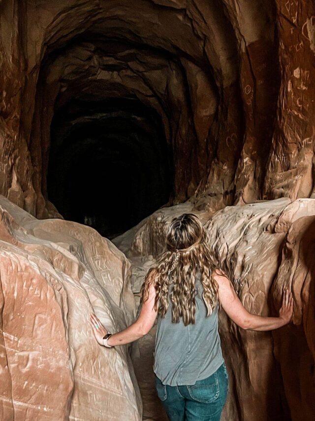
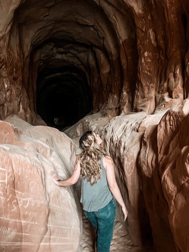
3. The Belly of the Dragon Trail
Difficulty: Easy
Length: 1.8 miles
Type: Out & back
AllTrails Link: The Belly of the Dragon
Belly of the Dragon is a really fun stop in southern Utah and is another one of the best Kanab hikes.
The trailhead is close to Zion National Park and is only a few miles outside of Kanab, Utah.
It is actually an old drainage tunnel that runs underneath Hwy 89, but it resembles the inside of a dragon’s belly and is fun for everyone to hike through.
The tunnel is long enough that it can be pretty dark in the middle, so be sure to bring a flashlight with you.
Once you reach the far side of the tunnel, you can continue on through the wash to complete the rest of the hike.
There is a four or five-foot drop to get down into the tunnel and climb back out, but it is relatively easy to maneuver.

4. Toadstool Hoodoos Trail
Difficulty: Easy
Length: 1.8 miles
Type: Out & back
AllTrails Link: Toadstool Hoodoos Trail
Although not as grand as the nearby Goblin Valley hoodoos and Bryce Canyon hoodoos, the Toadstool Hoodoos trail is still fun and is quite unique.
The trail is quite easy at less than 2 miles round trip, but there are a few steep cliffs, so you may avoid this hike if you are afraid of heights.
This trail is located in Grand Staircase Escalante National Monument just outside of Kanab, Utah.
The Toadstool Hoodoos Trail is almost as fun as the hoodoos themselves!
You will start off in a wash, although it wasn’t too sandy, thankfully. After a short time, you will climb above the wash.
There are a few sections where you walk across a bridge-like section with drop-offs on both sides.
Once you reach the Toadstool Hoodoos, you can explore the surrounding area and take pictures before returning.
There is only an elevation gain of 141 feet, so it really is a relatively easy hike for almost anyone. Even our dogs thoroughly enjoyed the hike!

Southern Utah Hiking Trails Near Moab
5. Corona and Bowtie Arch Trail
Difficulty: Moderate
Length: 2.4 miles
Type: Out & back
AllTrails Link: Corona and Bowtie Arch Trail
Located just outside of Moab, Utah, Corona Arch is one of the less-known hikes in the area.
While Corona Arch is an impressive rock formation, it receives very few visitors compared to Arches National Park and other popular places near Moab.
This is a 2.3-mile moderate hike that takes you to the red rock of Utah’s backcountry. The hike is located just off Utah Scenic Byway 279 and doesn’t require a permit or fee.
All you need to do is park your car and walk toward the beginning of the trail.
Come here early morning, and you will meet very few people, and if you come on a weekday, you might even have the whole place to yourself!
While this is essentially a flat trail, some sections of the hike are more challenging than others, and you will also have to climb a ladder to transition between different sections of the hike, so hiking shoes with a good grip will be your best friend on this hike.
Additionally, this hike has no facilities, and the signage is minimal.
When hiking this trail, you will mostly find cairns – piles of rocks that serve as markers telling you that you are on the right way.
By the end of the hike, you will arrive at an impressive sandstone arch that is surrounded by red rock landscapes in all directions.
This is a remote area, so bringing enough water and snacks is important. Although this is not a long trail, you could get dehydrated quickly, especially if you hike in summer when it can be hot and dry.
Plan about 2 hours for this trip because you will most likely want to take pictures at the arch once you get there.
Recommended by Daria B. of The Discovery Nut

6. Leprechaun Canyon Trail
Difficulty: Moderate
Length: 2.2 miles
Type: Out & back
AllTrails Link: Leprechaun Canyon
One of the best-underrated hikes in Utah is Leprechaun Canyon. This hike is outstanding due to its remoteness and beautiful slot canyons.
The trail is just over 2 miles round-trip with an elevation gain of 141 ft. It features a very narrow slot canyon as well as a large open canyon.
This is an excellent hike for the whole family since it is relatively easy.
The trail is located off Highway 95, south of Hanksville. If you are around Goblin Valley State Park, this is an easy getaway.
You only need a maximum of 2 hours to complete. The best time to go is during the day on a weekday so you can have the trail all to yourself.
Sadly, dogs are not allowed on this trail, which is fine because the slot canyons can get pretty tight.
If you are a rock climber or canyoneer, you can go further on the trail using ropes; just be watchful of the weather and make sure there is no rain in the forecast.
Even if you are not an advanced climber, this is still a fantastic trail that should be on everyone’s bucket list.
Recommended by Michelle S. of The Wandering Queen

Southern Utah Hiking Trails Near St. George
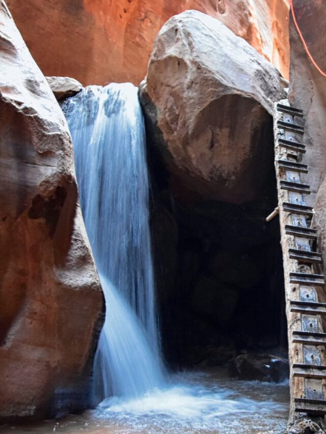
7. Kanarra Creek Canyon Waterfall Trail
Difficulty: Moderate
Length: 3.7 miles
Type: Out & back
AllTrails Link: Kanarra Falls
On the road between Las Vegas and Page in Southern Utah, the Kanarra Creek Canyon Waterfall hike is comparable to Zion National Park’s Narrows, albeit smaller and with fewer crowds.
This moderate 3.7-mile out-and-back hike trudges through unavoidable ankle-to-knee-deep chilly water along the towering sides of a beautiful slot canyon before reaching the highlight of the trip: the picturesque ladder next to the Kanarra Creek Waterfall.
We recommend that you climb up the ladder to continue exploring the depths of Kanarra Creek Canyon.
Shortly after, a questionable log ladder challenges hikers to continue onwards or return.
For those brave enough to venture up, the following deep pools will force you to hike sideways between the canyon walls or wade through waist-deep waters.
The Kanarra Creek Canyon waterfall hike is one of the best waterfall hikes in Southern Utah, but you may want to steer clear in the winter months.
This hike is best done in the spring or summer when the weather and the creek’s waters are warmer.
It is a moderate hike, following the creek for the first half before arriving at the entrance to the canyon.
It’s best to time the hike so you will be in the canyon around mid-day for optimal sunshine.
This hike can be completed in about 2-3 hours if you plan to return after reaching the second ladder.
A $12/person fee is required to enter Kanarra Creek Canyon, which is limited to 150 daily permits.
To ensure that you receive a permit, reserve your ticket online.
Recommended by Catherine X. of Nomadicated

8. Cinder Cone Trail
Difficulty: Moderate
Length: 1.7 miles
Type: Out & back
AllTrails Link: Cinder Cone Trail
Have you ever wanted to hike to the top of a volcano? You may be surprised to learn that you could actually check that off your bucket list in Southern Utah!
While this area may be more famous for red sandstone cliffs, there was quite a lot of volcanic activity here, and if you pay close attention, you’ll see lots of black lava rock, even in places like Capitol Reef and Zion.
To hike a volcano, head to Snow Canyon State Park, just a few minutes north of St. George, Utah.
Just outside the north entrance to the park sits the Santa Clara Volcano, which last erupted 27,000 years ago and formed two cinder cones.
The north cinder cone sits on private land and has no marked trails, but the south cinder cone features a 1.7-mile round-trip trail called Cinder Cone Trail.
Once you hike to the top, you can circle the entire rim of the volcano and scope out some of the best views of the red and white sandstone cliffs of Snow Canyon or even descend into the cinder cone if you so desire.
The trailhead only has a few parking spots, but it sits outside of the popular state park, so it is rarely busy.
This is a real hidden gem but one of the best bucket-list-worthy hikes in Southern Utah.
Recommended by JJ of The Mini Van Bucket List

9. Yant Flats Trail
Difficulty: Moderate
Length: 3.4 miles
Type: Out & back
AllTrails Link: Yant Flats Trail
One of the most unique hikes in Utah is also an overlooked hike near the city of St. George in the southwest corner of the state.
The hike to Yant Flat is mostly along a dirt path through a forested area. It’s a mild trail with a slight incline and a sandy path towards the end.
The trail itself is pretty uneventful, but what makes this trail worthwhile are the Candy Cliffs.
The Candy Cliffs are incredible formations of orange and gray swirled rocks that you’ll reach at the trail’s end. The rock pattern looks like a dragon’s back, and the coloring is very unique.
This section of the hike is very exploratory and can be strenuous if you want to hike up and down the colored swirls. You’ll also get great views of the distant mountains.
The best time to hike Yant Flat is early in the morning or later in the afternoon, as the Candy Cliffs are entirely exposed to the sun.
The hike takes about an hour and a half to two hours, depending on how long you want to explore the cliffs.
It’s well worth the hike and gives you some different landscapes to check out in Utah.
Recommended by Ashley J. of Jetset Jansen

Southern Utah Hiking Trails in National Parks
Some of the best southern Utah hiking trails are found in Utah’s fabulous national parks.
If you already own an America the Beautiful Park Pass, you can get into the national parks without paying any extra fees.
Please note: Some parks require timed entry permits or shuttle tickets.
Hiking Trails in Arches National Park
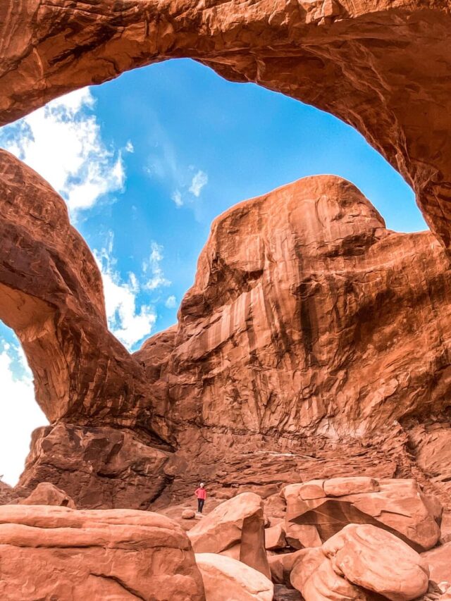
10. Devils Garden Trail
Difficulty: Hard
Length: 7.9 mile
Type: Loop trail
AllTrails Link: Devils Garden
Devil’s Garden is located at the far end of the road that goes through Arches National Park.
The hike is divided into three connected trails. To do all three is a strenuous hike totaling 7.9 miles, which takes about six hours.
There are eight arches along the whole route, making this a highlight of any visit to the national park.
If you’re attempting the whole trail, leave early in the morning to beat the worst of the heat, especially in summer when temperatures can be brutal.
There is no fee or permit to do the hike itself, though there is an entrance fee for Arches National Park of $30 per vehicle.
The park also requires a timed entry permit from early April to early October, and this costs an additional $2.
The trail starts with the easy hike to Landscape Arch, the longest single-span arch in North America.
A short trail goes to Pine Tree and Tunnel Arches. This section is 0.95 miles and takes about 35 minutes each way.
Many people stop there, but if you are up for an adventure, head across the top of a sandstone fin and hike deeper into Devil’s Garden to the spectacular Double O Arch.
Side trails take you to Navajo Arch and Partition Arch, which you can look through and see people down below looking at Landscape Arch.
When you get to Double O Arch, climb through the lower arch and then look back for a breathtaking view of them both, with beautiful sandstone fins beyond.
It’s a 2.1-mile each-way moderate trail to Double O Arch. From there, you can return the way you came or continue along the strenuous primitive trail and loop back to the start.
You will need to follow cairns and other trail markers, climb along narrow ridges, and possibly wade through water. The trip through Fin Canyon, with a short side trip to Private Arch, is amazing but challenging.
No matter which of the hiking trails in Arches National Park you choose, you will love Devil’s Garden.
Recommended by James I. of Parks Collecting

11. Delicate Arch Trail
Difficulty: Moderate
Length: 3.2 miles
Type: Out & back
AllTrails Link: Delicate Arch Trail
It’s no wonder that Arches National Park is one of the most popular of the Mighty Five in Utah to see the state’s natural beauty.
With over 2,000 documented stone arches, it’s also no secret where the park got its name.
Among the most popular and unique is the Delicate Arch, a 52-foot free-standing arch, which has become a popular symbol known by the entire state.
The hike to reach Delicate Arch is a moderate 3.2-mile roundtrip hike.
Although the trail is rated as moderate, there are definitely points that are tough and require a few extra water breaks.
There also is almost no shade along the trail, so it’s recommended to visit early in the morning or in the off-season.
Along the entire trail, you’ll be surrounded by the park’s beauty, from arches to red rocks to mountains in the distance.
Plan to set aside about 2 hours to complete the hike to Delicate Arch, and more if you plan to take your photo in front of it.
Because of this trail’s popularity, there will likely be many people waiting in line for their photos to be taken!
This hike is located in a national park, so you will need either a weekly ($30) or annual ($80) pass to enter.
The park also implements a timed entry reservation system, and all visitors must have a reservation.
Recommended by Kassidy O. of The Hiking Helper

Hiking Trails in Canyonlands National Park
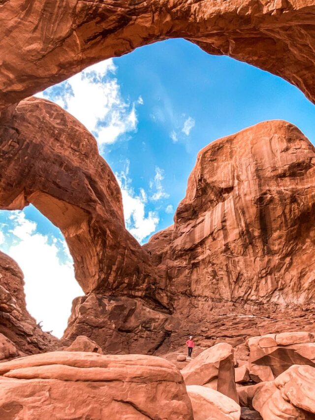
12. Mesa Arch Trail
Difficulty: Easy
Length: 0.7 miles
Type: Loop trail
AllTrails Link: Mesa Arch Trail
One of the easiest and best hikes in Southern Utah is the hike to Mesa Arch.
This is a famous photo spot that many people erroneously assume is in Arches National Park, but it’s actually located in Canyonlands National Park, about a 30-minute drive north of Moab.
You will need to pay a $30 vehicle fee to enter Canyonlands unless you already have a national park pass.
The hike to Mesa Arch is easily done via a 0.7-mile loop, bringing you to the arch! However, note that the path is not paved and is a bit rocky.
You will need to watch your step while hiking this trail, which is not ADA-accessible. Despite its short length, it may be difficult for families using strollers or elderly people.
While the hike is short, about 20-30 minutes, including some time for photos, the payoff is terrific!
Mesa Arch is located on a cliff, so it frames the canyon below it perfectly.
The views of the La Sal Mountains in the distance add to the magic. You can also walk up to the arch for a great photo opp.
The hike is busiest at sunrise when the sun comes up for that famous “sunburst” effect, where the rising sun shines through the arch.
However, it’s usually pretty quiet at other times of the day and equally as spectacular!
While you should definitely also do some of the other arch hikes in the region, such as Delicate Arch and Corona Arch, you really shouldn’t leave a visit to Mesa Arch off of your Moab itinerary!
Recommended by Allison G. of Eternal Arrival

13. Grand View Point Trail
Difficulty: Easy
Length: 1.8 miles
Type: Out & back
AllTrails Link: Grand View Point Trail
One of the best hiking trails in southern Utah is Grand View Point in Canyonlands National Park.
Often overlooked by its popular sister park, Arches, the hiking in Canyonlands is far superior for views.
Canyonlands National Park has three regions – Island in the Sky, The Needles, and The Maze.
Island in the Sky is more popular for visitors because it’s close to Moab, Utah, and the other two regions are more remote.
Grand View Point Trail is one of the best hikes in Canyonlands National Park.
It’s located in the Island in the Sky district, and it does not require a reservation or entry fee beyond the typical park entrance fee.
Hiking to Grand View Point, you’ll get stunning views of the canyon nearly the entire way.
Canyonlands offers massive canyon views, similar to the Grand Canyon but on a smaller scale.
Grand View Point Trail is an out-and-back trail coming in at just 2 miles and rated as easy.
Expect to take an hour during this hike or longer if you make lots of stops for rest or photos.
This hike is best done in spring or fall to avoid the summertime heat in southern Utah or the snow in the winter.
However, if you’re visiting the region during summertime, go early in the morning, as there’s no shade during this hike.
Recommended by Nikki of She Saves She Travels

Hiking Trails in Zion National Park
14. Observation Point via East Mesa Trail
Difficulty: Moderate
Length: 7 miles
Type: Out & back
AllTrails Link: Observation Point via East Mesa Trail
Observation Point, in Zion National Park, leads to one of the most spectacular overlooks of the Zion Canyon.
To access this 7-mile trail, you’ll need to drive to the East Mesa trailhead, which is right outside the park’s eastern border.
As such, you won’t need to pay the park’s $35 entrance fee to access this trail (although you will need to pay the fee to explore the rest of this fantastic park!).
This moderate trail meanders along a reasonably flat pathway through a pine forest.
While you’ll hike through beautiful trees, the trail has limited shade, so your best bet is to start this hike on the early side and bring plenty of water.
Along the last mile of the hike, you’ll get glimpses of the canyon below, with the endpoint providing spectacular panoramic views straight down the Zion Canyon.
You’ll even get a bird’s eye view of the famed Angel’s Landing over 600 feet below!
Be sure to save up some energy for the return trip, though, as the trail slopes downhill to reach the overlook, so you’ll have to make a 702-foot climb back to the trailhead.
On average, it usually takes hikers two and a half to three hours to complete this hike – but be sure to build in lots of time to take pictures once you reach Observation Point!
Recommended by Jessica S. of Uprooted Traveler

15. Zion Narrows Bottom-Up to Big Springs Trail
Difficulty: Hard
Length: 8.9 miles
Type: Out & back
AllTrails Link: Zion Narrows Bottom-Up to Big Springs
The Narrows is one of Utah’s most famous hiking trails!
Located in Zion National Park, this strenuous hike through a scenic slot canyon requires you to get your feet and sometimes much of your body wet, as the hiking trail is in the Virgin River.
Because you will spend a good portion of the hike in water, summer is the best time to hike The Narrows.
The water temperature can be freezing during other times of the year, and the canyon is more prone to flash flooding during rainy seasons.
Despite being rated a challenging trail, you can easily hike portions of The Narrows with children if visiting Zion with kids.
There are two ways to hike The Narrows, the most popular hike being the Bottom-Up Trail. This out-and-back trail starts at the Temple of Sinawava via the Riverside Walk trail in Zion.
You can hike approximately 10 miles from this trailhead without a permit, but most people hike about 3 miles to a point on the trail called Wall Street before turning around.
The other way to hike the Narrows is Top-Down. This 16-mile trail is a huge challenge that can be done either as a strenuous one-day hike or, more often, an overnight through-hike.
Remember when planning to hike The Narrows that your hike will take twice as long as a traditional hike because you will be hiking in water and on extremely slippery river rocks.
For this season, hike poles are strongly recommended!
Recommended by Melissa from Parenthood and Passports

16. Angels Landing Trail
Difficulty: Hard
Length: 4.4 miles
Type: Out & back
AllTrails Link: Angels Landing Trail
The Angels Landing hike should be on the list of anyone looking for the best hiking trails in southern Utah.
This epic hike is considered one of the most dangerous and rewarding in the world.
Part of the hike traverses a narrow sandstone ridge with 500-foot drop-offs on either side. But the hike is worth the view of this beautiful Utah landscape!
Hikers use chains to protect them from the extreme exposure of the route.
Hikers with a fear of heights will definitely be challenged by Angels Landing.
Angels Landing is in Zion National Park. You will need a park pass at $35 for a week.
The trailhead is at the Grotto past Zion Lodge. The park shuttle is the best way to access it.
The hike is 4.4 miles round trip, and you should allow 3-4 hours for the trek.
The hike starts with a pleasant walk through the shady Refrigerator Canyon on the West Rim trail.
Soon, you will encounter Walter’s Wiggles, a series of switchbacks ascending 250 feet up the canyon.
Rest and stop at the top at Scout Landing for views of the valley and the steep hike to come.
From here, the chain section up Angels Landing starts and is the most challenging part of the hike.
Once on the summit, you will have panoramic views of spacious Zion Canyon, one of the many amazing canyons in southern Utah.
The best time to go is in the spring or fall when the temperature is lower. Avoid the crowds by hiking very early in the day.
Recommended by Karen W. of Outdoor Adventure Sampler

Hiking Trails in Bryce Canyon National Park
17. Bryce Canyon Rim Trail
Difficulty: Moderate
Length: 10.7 miles
Type: Out & back
AllTrails Link: Bryce Canyon Rim Trail
The Rim Trail is one of the easiest hikes in Bryce Canyon National Park, with fantastic photo opportunities.
A mostly paved and then graveled path, the Rim Trail is flat and easy to do, so it is perfect for all age groups to enjoy without excessive hiking down into the canyon areas unless you continue to more of the challenging parts of the hike.
It almost feels like every corner or new area you walk through is a picture-perfect moment and always changing, so the Rim Trail is visually stimulating and rewarding for visitors who love to take pictures or even selfies to enjoy the magnificent views along the trail.
The entire trail goes approximately 5 miles in each direction with many elevation changes, but you can go the distance you want and head back in the same direction you came from.
If you are up for the challenge, the Rim Trail takes you through some spectacular scenery with over 1754 feet in elevation change.
Take in what you are interested in doing along the trail and head back when you have challenged yourself enough on this fantastic hike.
It is an awe-inspiring hike in Bryce Canyon and rewarding to experience all or just a part of this hike in Bryce Canyon National Park.
Recommended by Noel M of The Mature Traveler

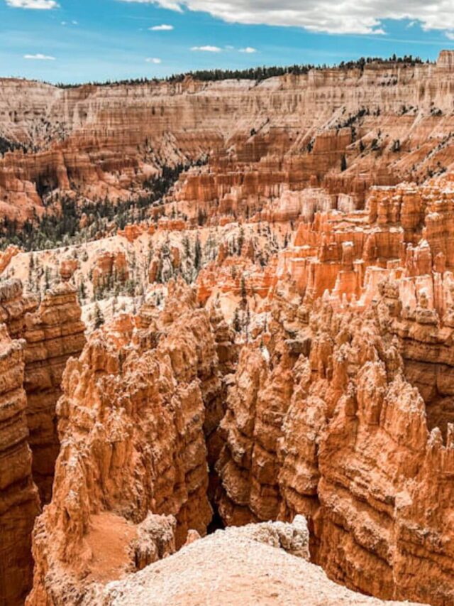
18. Wall Street and Queens Garden Loop Trail
Difficulty: Moderate
Length: 3.2 miles
Type: Loop trail
AllTrails Link: Wall Street and Queens Garden Loop Trail
One of the most beautiful hikes in Bryce Canyon National Park is the Wall Street and Queens Garden Loop Trail.
This is one of the most popular trails in the park because you are able to hike down into the gorgeous hoodoos. The views are incredible!
There are some steep switchbacks along this trail, and an elevation gain of 643 feet makes this a more moderate trail.
It is recommended to bring plenty of water and leave yourself enough time to take breaks as needed.
The Fairyland Loop Trail is also very popular but is 7.8 miles round-trip.
I recommend sticking with the Wall Street and Queens Garden Loop Trail if you’re not up for a difficult challenge.
If you can, consider visiting this area in the winter. There are fewer visitors to the park in the winter months, so these popular trails aren’t quite as slammed.
Additionally, if you are lucky enough to visit on a day when it is snowing, the contrast of the white snow falling through the bright red and orange hoodoos is stunning!
Located in one of my two favorite Utah national park areas, this is undoubtedly worthy of being one of the best national park bucket list hikes!

Hiking Trails in Capitol Reef National Park
19. Hickman Bridge Trail
Difficulty: Moderate
Length: 1.7 miles
Type: Out & back
AllTrails Link: Hickman Bridge Trail
Utah is home to tons of incredible hikes, but one of the all-time best is the Hickman Bridge hiking trail in Capitol Reef National Park.
It is a fun, 1.7-mile long, moderately difficult, out-and-back trail that will take just under an hour to complete.
This trail takes you along a series of switchbacks that level off and take you to a fork in the trail.
But, the best part? You’ll see local treasures like Cohab Canyon and Nels Johnson Bridge and take in panoramas of Capitol Dome on the horizon.
Once you make it to the fork, go right and go under the bridge to take in some of the most impressive desert views in the entire area.
Because this trail is one of the best hikes in Capitol Reef, you’ll want to get up early and hit the trail before sunrise to avoid the crowds.
You’ll also want to always stay on the designated trail, avoid narrow canyons, and stay away from cliff edges while here.
Recommended by Jamie of Photo Jeepers

20. Cassidy Arch Trail
Difficulty: Moderate
Length: 3.1 miles
Type: Out & back
AllTrails Link: Cassidy Arch Trail
Capitol Reef is Utah’s least visited national park, but it still has much to offer.
One of the best things to do in the park is a hike to Cassidy Arch. This trail leads to a stunning view of a giant arch with gorgeous scenery along the way.
If you only have one day in Capitol Reef, the Cassidy Arch trail should be on your list.
As you drive to the trail, be prepared for a short, unpaved road, but any car should be able to make it.
It is best to hike this trail in the morning to beat the heat and the crowds. Allow 1-2 hours to complete the hike and take some photos.
The Cassidy Arch trail is just over 3 miles long with over 600 feet in elevation gain.
The elevation gain is pretty steady, but some steep and rocky sections make the trail difficult.
During the hike, you’ll enjoy views of colorful rocks as you look down at Grand Wash.
When you reach the top, you can get an amazing view standing directly across from the arch and even walk across the top!
You may even see people rappelling down from the arch (which requires a permit).
Recommended by Lydia W. of Lost With Lydia

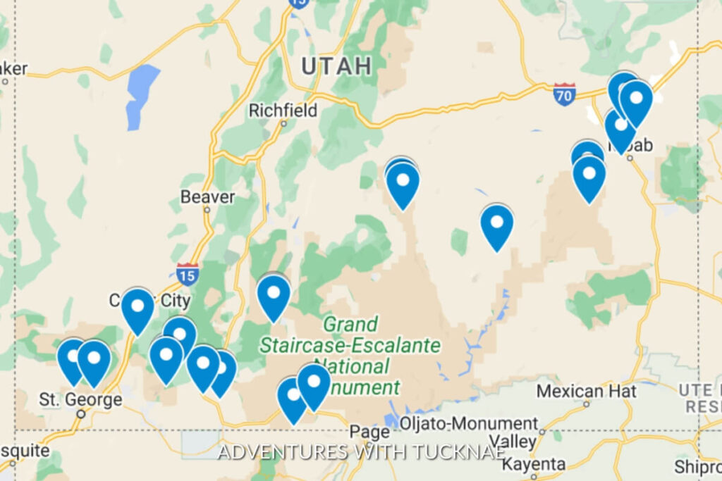
Southern Utah Hiking Trails Map
Below is a map I put together showing the location of every hiking trail on this list! Click here to access all of the map details.
In Closing: 20 of the Best Epic Hiking Trails in Southern Utah
And there you have it! These are the best hiking trails that Southern Utah has to offer.
When you’re hiking, be sure to bring lots of water. The weather in southern Utah is known to be brutally hot, and you can get dehydrated quickly if you are not prepared.
Also, always check the weather before you begin hiking, and do not enter any canyons (especially slot canyons) if there is rain in the forecast in your area.
I hope that you have found this list of the best hiking trails in southern Utah inspiring!
Which one is at the top of your bucket list? Let me know in the comments below!
Find More Utah Travel Adventures & Inspiration
- 2026 Guide to Visiting Belly of the Dragon – Kanab, Utah
- 20 of the Best Epic Southern Utah Hiking Trails
- 15 of the Best Utah Slot Canyons in Southern Utah
- Top 50+ Amazing Things to Do in Southern Utah in 2026
- 15 of the Best Hikes in Arches National Park (2026 Guide)
- ATVing & Canyoneering with Kanab Tour Company
- The Top 10 Best Waterfalls in Southern Utah in 2026
- Top 32 Most Instagrammable Places in Utah in 2026
- 101 Best Utah Quotes & Captions for Instagram
- The 10 Best Hikes Near Kanab, Utah, with Amazing Views
Read More of Our National Park Hiking Guides
Happy hiking!